
 English
ATLANTIC HURRICANE SEASON 2024 – WARNING TO SEAFARERS
Published: 18 June 2024
The Atlantic hurricane season starts on 1 June and ends on 30 November. The National Oceanic and Atmospheric Administration (NOAA) predicts an above-normal 2024 Atlantic hurricane season. NOAA is forecasting 17 to 25 storms with winds of 39 mph (34 knots) or higher. Out of these, 8 to 13 could become hurricanes with winds of 74 mph (64 knots) or higher, and 4 to 7 might be major hurricanes with winds of 111 mph (96 knots) or higher.
BEST PRACTICES FOR SHIPS SAILING ATLANTIC IN HURRICANE SEASON
PRIOR SAILING
- Prepare a comprehensive voyage risk assessment when navigating in the Atlantic basin
- Subscribe to weather routing services to prepare the ship for any development of hurricanes or heavy weather before and during the voyage
- Ensure the water and weather tightness of the ship’s compartments and openings
- Secure and prepare the vessel in all aspects for extreme heavy weather and consider taking extra lashing to prevent any cargo shifting
- Train crew members on avoiding heavy weather and handling the ship if heavy weather is encountered. Inform crew of the emergency response procedures in the Safety Management System (SMS) for heavy weather damage. All watchkeeping deck officers should familiarise themselves with reading and understanding weather reports and charts
- Tune to the correct met area and satellite to receive meteorological warnings and forecasts through enhanced group calling (EGC) services
- Identify weather facsimile stations and their transmission frequencies in the area to receive weather facsimile charts.
DURING SAILING
- Regularly inspect the lashing arrangements of cargo, equipment, and fittings to ensure the vessel is prepared for potential extreme weather conditions
- Receive and plot weather warnings from weather routing services and EGC services
- Compare the predicted path of heavy weather or hurricane-force conditions against the vessel’s progress.
UPON ENCOUNTERING
- Continually compare the hurricane’s forecast track to the planned ship movement
- The 1-2-3 rule of thumb can be used for forecasting the error radius (100 Nautical Miles [NM] for 24 hr, 200 NM for 48 hr, 300 NM for 72 hr forecast) and to determine the danger area, see Figure 1
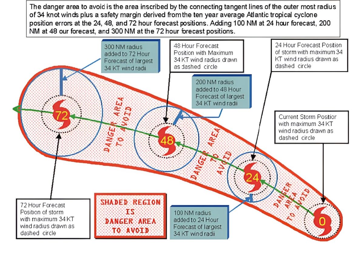 Figure 1 – Diagram of the 1-2-3 Rule
Source – National Oceanic and Atmospheric Administration (NOAA) website
- Plot the danger area chart to identify the areas to avoid based on the hurricane path.
- Determine at least 2 possible courses of action for the vessel to remain clear of the danger area
- Evaluate nearby ports or hurricane havens that could be used for avoidance if needed
- Calculate the Closest Point of Approach (CPA) to the cyclone for the potential courses of action using the latest forecasts
- Decide on which avoidance course to take and execute it, while continuing to closely monitor the hurricane progress
- MSC.1/Circ.1228 gives guidance to the master for avoiding dangerous situations in adverse weather and sea conditions
- Follow the SMS procedure for encountering heavy weather
- Vessels in ports should evaluate the protection offered by the port based on forecast wind direction and storm surge potential
- Decisions to leave port for avoidance must be made very early, considering safe departure time and avoidance routes.
AFTER ENCOUNTERING HEAVY WEATHER
- Inspect the forecastle area and anchor lashing only after taking necessary precautions and conducting risk assessments, considering the dangers of being hit by waves or washed overboard (refer to our case study on the risks of heavy weather)
- Ensure comprehensive logbook entries detailing the facts and measures are completed,
HURRICANE CLIMATOLOGY IN NORTH ATLANTIC
In the North Atlantic, there are climatologically favoured regions and tracks for hurricane development and movement. Knowledge of hurricane climatology will aid mariners in avoiding these areas. For more information about Atlantic hurricane activity, please refer to this link.
For further information, please do not hesitate to email lossprevention@tindallriley.com.